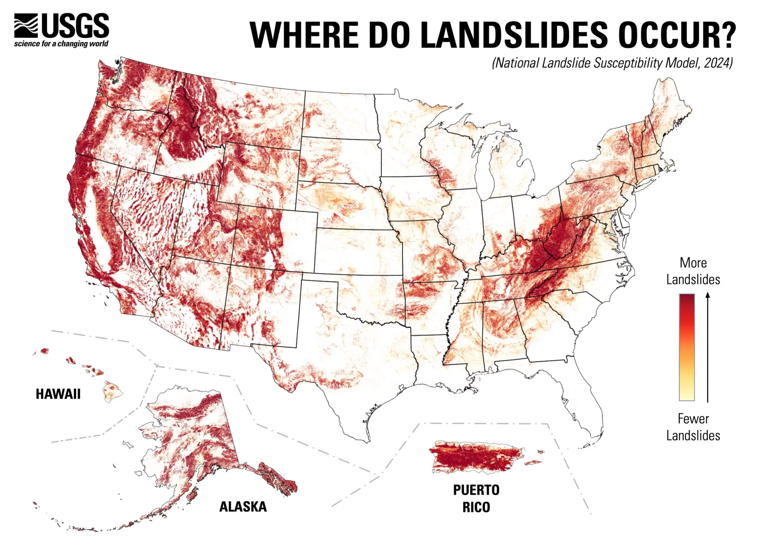
Landslides are a significant geological hazard that can result in devastating consequences, from loss of life to extensive property damage. Recently, the U.S. Geological Survey (USGS) unveiled a groundbreaking nationwide landslide susceptibility map, revealing that nearly 44% of the United States is at potential risk for landslide activity. This comprehensive assessment has the power to reshape how we understand and mitigate the threat posed by landslides across the country.
The innovation of the USGS’s new map lies in its county-by-county granularity, allowing for an unprecedented look at regions prone to landslides. Unlike previous assessments, which were limited to high-risk areas, this new approach captures a broader spectrum of susceptibility across the nation. The map not only pinpoints high-risk regions but also highlights areas where the risk is minimal. Such detailed information is essential for local planners and engineers, facilitating more informed land-use decisions and risk-reduction strategies.
The creation of this detailed map was made possible through the utilization of a variety of advanced technologies and large datasets. The research team compiled nearly a million records of prior landslide occurrences alongside high-resolution elevation data from the USGS 3D Elevation Program. This combination of historical data and cutting-edge technology enabled the team to craft a more accurate and reliable landslide susceptibility model. With this innovative mapping, local governments can prioritize efforts in areas identified as vulnerable, thus enhancing community preparedness.
The ramifications of this map extend beyond mere awareness. The availability of such detailed assessments will empower state and local policymakers to make more educated decisions regarding land use and development. By identifying regions at higher risk for landslides, planners can impose stricter building regulations and design infrastructure that can withstand geological disruptions. This proactive approach not only protects lives but also mitigates financial losses associated with potential landslide events.
While the new landslide susceptibility map is a monumental step forward, it also underscores the need for ongoing research and data collection. Identifying areas that require more detailed mapping is crucial for refining risk assessments and improving mitigation efforts. Additionally, engaging the community in understanding these risks through education and awareness campaigns will be vital in fostering a culture of preparedness.
The USGS’s nationwide landslide susceptibility map marks a significant advancement in geological hazard preparedness and risk management. By shedding light on the complexities of landslide risks across diverse regions of the United States, this initiative is a crucial tool for enhancing public safety. As communities leverage this information to bolster their resilience, the nation as a whole can move towards being a safer, more hazard-ready society capable of facing the challenges posed by natural disasters.


Leave a Reply