The Tianwen-1 mission by China’s National Space Administration (CNSA) has brought a new wave of excitement to the scientific community with its array of robotic elements aimed at unraveling the mysteries of the Red Planet. Consisting of an orbiter, a lander, two deployable cameras, a remote camera, and the Zhurong rover, this mission marks the beginning of a series of interplanetary endeavors by the CNSA.
One of the primary objectives of the Tianwen-1 mission is to delve into Mars’s geology and internal structure, study its atmosphere, and search for evidence of water on the planet. Additionally, like its predecessors, Tianwen-1 is on the lookout for traces of life on Mars, both past and present. With almost 1298 days spent exploring Mars, the mission’s orbiter has amassed a wealth of remote-sensing images of the Martian surface.
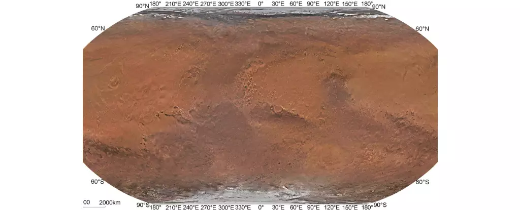
A team of researchers from the Chinese Academy of Sciences (CAS) undertook the mammoth task of stitching together these images to create the first-ever high-resolution global color-image map of Mars with spatial resolutions exceeding 1 km (0.62 mi). Led by Professor Li Chunlai and Professor Zhang Rongqiao, the team’s efforts culminated in the publication of their research in the journal Science Bulletin.
While previous missions have generated global maps of Mars using remote-sensing imagery, the resolution achieved by the CAS team using Tianwen-1 orbiter images surpasses all previous attempts. For instance, maps derived from missions such as Mariner 9, Viking 1 and 2, Mars Global Surveyor, Mars Reconnaissance Orbiter, Mars Express, and Mars Odyssey, lag significantly behind in spatial resolution compared to the Tianwen-1 map.
The Technological Marvel
The Tianwen-1 mission’s orbiter, equipped with the MoRIC instrument, has captured a staggering number of images during its orbits around Mars, ranging in spatial resolutions from 57 to 197 m (62 to 215 yards). Moreover, the Mars Mineralogical Spectrometer onboard the orbiter has gathered vital data in the visible and near-infrared bands, contributing to the comprehensive coverage of the Martian surface.
By utilizing advanced image processing techniques and optimizing orbit measurement data, the CAS team successfully fused individual images into a seamless global mosaic of Mars. Color correction techniques further enhanced the authenticity of the true colors of the Martian surface, resulting in the creation of the Tianwen-1 Mars Global Color Orthomosaic 76 m v1, boasting a spatial resolution of 76 m (83 yards) and setting a new standard in global mapping of Mars.
Future Implications
The high-resolution true-color map of Mars produced by the Tianwen-1 mission not only aids in scientific exploration but also serves as a critical reference for future missions to the Red Planet. As space agencies gear up for crewed missions to Mars in the coming years, this detailed map will play a pivotal role in selecting landing sites and guiding robotic explorers in their quest to uncover Mars’ enigmatic past.
The Tianwen-1 mission’s groundbreaking achievements in mapping Mars have opened up a new chapter in our understanding of the Red Planet. With its unparalleled resolution and color accuracy, the global map generated by the mission paves the way for enhanced exploration and discovery, shaping the future of Martian exploration for years to come.
Leave a Reply